
The engineering industry is experiencing a technological transformation, and drone site surveys are at the forefront of this revolution. At Carroll Engineering, we’ve witnessed firsthand how unmanned aerial vehicles (UAVs) are changing the way we approach site assessment and data collection across southeastern Pennsylvania and New Jersey.
The Traditional Challenges of Site Surveying
Traditional surveying methods, while reliable, often present significant challenges for engineering firms and their clients. Ground-based surveys can be time-intensive, requiring surveyors to physically traverse difficult terrain, potentially hazardous areas, or large expanses of land. These conventional approaches often result in higher costs, extended project timelines, and safety concerns, particularly when dealing with industrial sites, steep slopes, or environmentally sensitive areas common throughout the Delaware Valley region.
Enter Drone Technology: A Game-Changer for Site Surveys
Drone site surveys have emerged as a revolutionary solution, offering unprecedented advantages for engineering projects throughout Pennsylvania and New Jersey. These sophisticated aerial platforms equipped with high-resolution cameras, LiDAR sensors, and GPS technology are transforming how we collect, analyze, and utilize site data.
Enhanced Accuracy and Precision
Modern surveying drones can capture incredibly detailed topographic information with centimeter-level accuracy. RTK (Real-Time Kinematic) technology enhances accuracy to within centimeters, while systems provide horizontal accuracy down to 1 cm and vertical accuracy within 3 cm. Using photogrammetry and advanced mapping software, these aerial platforms create precise 3D models, orthomosaic maps, and digital elevation models that surpass traditional surveying methods in both detail and reliability. This level of precision is particularly valuable for complex engineering projects across the varied terrain of Pennsylvania and New Jersey.
Dramatic Time and Cost Savings
What once required weeks of traditional surveying can now be accomplished in days or even hours with drone technology. A single drone flight can cover hundreds of acres, collecting comprehensive data that would traditionally require multiple survey teams working over extended periods. This efficiency translates directly into cost savings for our clients while accelerating project timelines significantly.
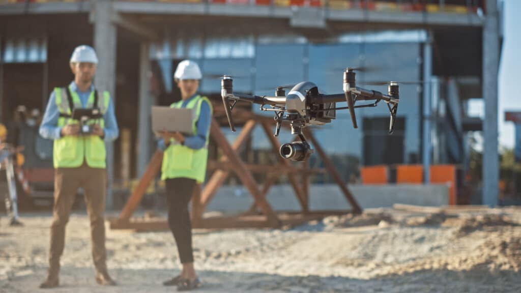
Improved Safety for Survey Teams
Safety remains paramount in engineering work, and drone site surveys eliminate many risks associated with traditional surveying methods. Rather than sending personnel into potentially dangerous areas — such as active construction zones, unstable terrain, or contaminated sites — drones can safely collect necessary data from above. This is particularly beneficial for industrial sites throughout the Greater Philadelphia Area and New Jersey.
Specific Applications Transforming Engineering Projects

Construction Site Monitoring
Drone surveys provide real-time progress monitoring for construction projects, allowing engineers to track earthwork volumes, identify potential issues early, and ensure projects stay on schedule and within budget. The ability to create regular volumetric calculations helps optimize material management and reduces waste.
Environmental Assessment
For environmental engineering projects, drones equipped with multispectral cameras can identify vegetation health, water quality indicators, and potential contamination areas. This capability is invaluable for brownfield redevelopment projects common in Pennsylvania and New Jersey’s industrial regions.
Infrastructure Inspection
Bridge inspections, utility line assessments, and facility evaluations benefit enormously from drone technology. High-resolution imagery and thermal sensors can identify structural issues, corrosion, or maintenance needs without requiring expensive access equipment or putting inspection teams at risk.
Flood Plain and Stormwater Management
With increasing focus on stormwater management and flood mitigation in the Mid-Atlantic region, drone surveys provide critical data for watershed analysis, flood modeling, and drainage design. The detailed topographic information collected helps engineers design more effective flood control systems.
Advanced Data Processing and Analysis
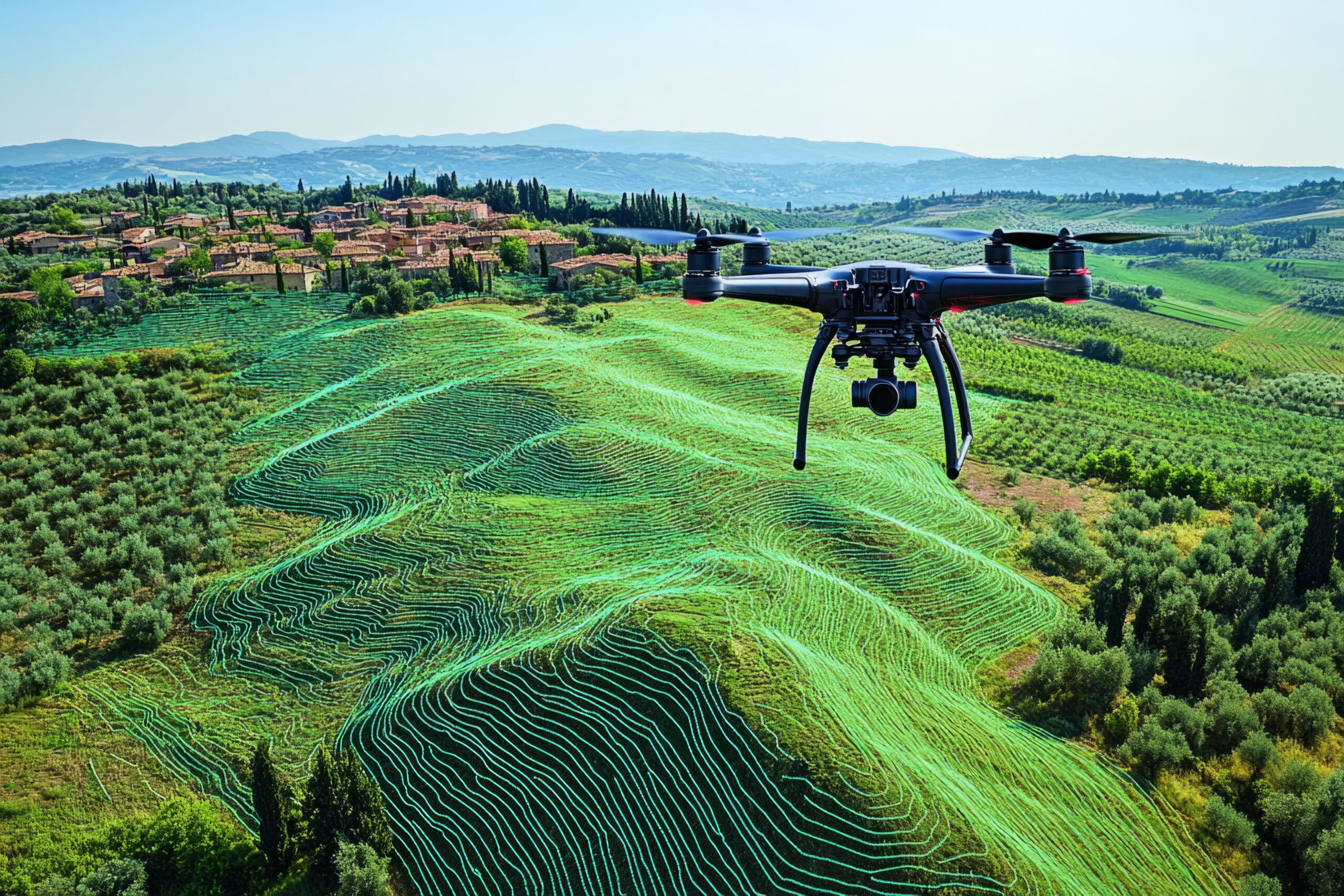
The value of drone site surveys extends far beyond simple image capture. Advanced software platforms process drone-collected data into actionable engineering information, including:
- Digital Surface Models (DSMs) for accurate terrain representation
- Volumetric calculations for earthwork and material estimates
- Contour maps and slope analysis for grading and drainage design
- 3D point clouds for detailed structural analysis
- Change detection to monitor site evolution over time
The Future of Site Surveying
As drone technology continues evolving, we anticipate even greater capabilities in the coming years. Artificial intelligence integration, improved sensor technology, and automated flight planning will further enhance the accuracy, efficiency, and value of drone site surveys for engineering projects throughout Pennsylvania and New Jersey.
Choosing the Right Engineering Partner
When selecting an engineering firm for your next project, consider their technological capabilities and commitment to innovation. Drone site surveys represent just one way that forward-thinking engineering companies are delivering better outcomes for their clients through advanced technology adoption.
At Carroll Engineering, we combine over 50 years of traditional engineering expertise with cutting-edge drone surveying capabilities to provide comprehensive site assessment services throughout Pennsylvania and New Jersey. Our investment in drone technology reflects our commitment to delivering accurate, cost-effective, and safe surveying solutions for projects of all sizes.
Whether you’re planning a project ranging from commercial development to infrastructure improvement and everything in between, drone site surveys can provide the detailed, accurate data necessary for successful project outcomes. Contact our Survey Manager, Justin Jurkowski, at jjurkowski@carrollengineering.com or (908) 512-7134 to learn how drone surveying technology can benefit your next project in Pennsylvania or New Jersey.
Sources
- (2024, August 1). “Best Drones for Site Surveying in 2024.”
- https://www.datumate.com/blog/best-drones-for-site-surveying-in-2024/
- Atom Aviation Services. (2025, February 1). “Why Drone Surveys Are Changing Construction Sites in 2024”
- https://www.atomaviation.com/why-drone-surveys-are-changing-construction-sites-in-2024-expert-guide/
- Crucial Services. (2024, January 10). “Exploring the Benefits of Drone Surveying in 2024.”
- https://crucialservices.net/exploring-the-benefits-of-drone-surveying-in-2024/
- (2024, April 12). “Surveying with a drone — explore the benefits and how to start.”
- https://wingtra.com/surveying-gis/