
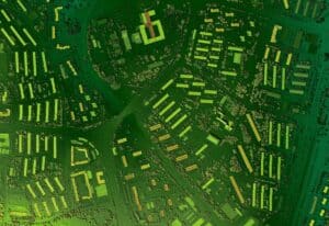
When it comes to operating a civil engineering firm, utilizing technology is a crucial component of enhancing work product and keeping our engineers on track. One of the ways Carroll Engineering accomplishes this is by utilizing GIS technology. GIS, or Geographical Information System, is computer software that interprets data gathered from a specific location and uses that data to create a geographically accurate model of said location, known as a GIS model. Our engineers collect data from all different types of methods—including survey data, topography soils, geology, traffic, imaging, and more—and then upload their findings to the GIS software. The software then reflects back all of these points at once via the GIS model. GIS technology makes juggling this data easier than ever, helping engineers create structures like roads, bridges, pipelines, and drainage systems safely, efficiently, and effectively.
Using GIS Modeling to Improve Safety Outcomes
By understanding the details and terrain of an area, engineers can maximize the safety of their projects. For example, GIS models can be used to simulate the natural terrain of an area and the effects of natural disasters on that area, allowing engineers to assess any risks and adjust safety considerations accordingly. GIS also accounts for hazards that are not weather related—for example, GIS can be used to analyze existing infrastructure, such as buildings or roads, for danger. From there, engineers can plan on how to improve these structures to be even safer, even using models to help prepare for future changes and considerations, modeling future scenarios based on other factors, such as population growth or expansion, to ensure that their designs stand the test of time.

Deploying GIS Capabilities to Save Time
GIS also helps engineers meet deadlines much more quickly. For example, GIS assists in designing systems by considering details about the terrain, land use, and existing infrastructure in an area, all at once. Manually creating plans based off each of these details could take weeks and multiple rounds of revisions, with little guarantee that everything would be accurate. However, with the GIS system running the data, it takes minutes. GIS can even integrate with drones and sensors to track construction progress, generating project management data and reports in a matter of seconds. This agility helps engineers and builders to get projects done in a timely manner, saving developers both time and money.
Effortlessly Optimize Projects
Perhaps the most recognized benefits of utilizing GIS models are the optimized outcomes its data analysis enables. By interpreting multitudes of data about a geographic area, GIS can utilize this information to identify optimal locations for construction, energy projects, or industrial facilities. The software can quickly visualize and analyze factors that humans may accidentally overlook, such as proximity to resources, environmental impact, and zoning regulations, and consider them when creating the most efficient and effective version of a plan. As well, the ability to analyze existing infrastructure and other patterns can help to improve new projects, such as creating optimized roadways. These models generate the most effective versions of a project, with little to no extra effort on the part of the engineer or developer.
Enhancing Carroll Engineering’s Results with GIS
Engineers have to juggle a multitude of considerations when planning, designing, and executing a project—and the process can be daunting.
In the engineering world, getting projects done in the most time-efficient, budget-friendly, and effective manner is critical for staying ahead of the competition. Therefore, Carroll Engineering’s use of GIS technology not only differentiates us, but allows us to deliver safe, highest-quality work products within an optimal time frame to each of our clients, whether it be a private venture, a municipal project, or anywhere in between. For more information, read about Carroll Engineering’s projects or GIS services.